


Waunakee - V 11 Voting District, Dane County, Wisconsin
About
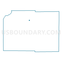
Outline

Summary
| Unique Area Identifier | 692977 |
| Name | Waunakee - V 11 Voting District |
| County | Dane County |
| State | Wisconsin |
| Area (square miles) | 0.23 |
| Land Area (square miles) | 0.22 |
| Water Area (square miles) | 0.00 |
| % of Land Area | 99.57 |
| % of Water Area | 0.43 |
| Latitude of the Internal Point | 43.18734740 |
| Longtitude of the Internal Point | -89.45248570 |
Maps


Graphs
Select a template below for downloading or customizing gragh for Waunakee - V 11 Voting District, Dane County, Wisconsin


Neighbors
Neighoring Voting District (by Name) Neighboring Voting District on the Map
- Waunakee - V 1 Voting District, Dane County, WI
- Waunakee - V 10 Voting District, Dane County, WI
- Waunakee - V 12 Voting District, Dane County, WI
- Waunakee - V 13 Voting District, Dane County, WI
- Waunakee - V 3 Voting District, Dane County, WI
- Waunakee - V 5 Voting District, Dane County, WI
- WESTPORT - T 1 Voting District, Dane County, WI